Key Skills For Mountain Weather Forecasting
Ellis Brigham have recently begun working with the Mountain Weather Information Service (MWIS), who's aim is to offer leading forecasts for the uplands of Britain, focusing on safety in the mountains.
Detailed and accessible weather information is aimed at both novice and experienced mountain users. Forecasts are issued by a small team of professional meteorologists 365 days a year, serving as a warning of the potentially life-threatening weather conditions which can exist on our mountains. Localised forecasts are provided for ten mountain regions across the UK.
Garry Nicholson has worked for the Mountain Weather Information Service since 2013, after completing a Masters degree in Meteorology from the University of Birmingham. Garry hails from the Derbyshire Peak District and is also a regular Lakeland fell walker. His background in Geography and Media are a vital asset in forecasting for the British mountains, interpreting and communicating the subtleties of UK local weather patterns. He is one of the chief MWIS forecasters and produces the video content for the MWIS YouTube channel.
Garry takes us through some key principles of mountain weather forecasting and aims to help you answer that eternal question of 'What's the weather doing?'
The British Isles sits at a real atmospheric crossroads. We’re sandwiched between a large continental landmass and a vast ocean, in the temperate mid-latitudes. We can be best described as having an equable maritime climate - rarely extreme by global standards - chiefly moderated by the influence of the Atlantic gulf stream.
At all times of year we can be easily influenced by weather patterns from every point on the compass. It is wind direction and the source of that air which holds the key to our day-to-day weather changes. It means our glorious British weather is ever variable and unreliable at all times of year!
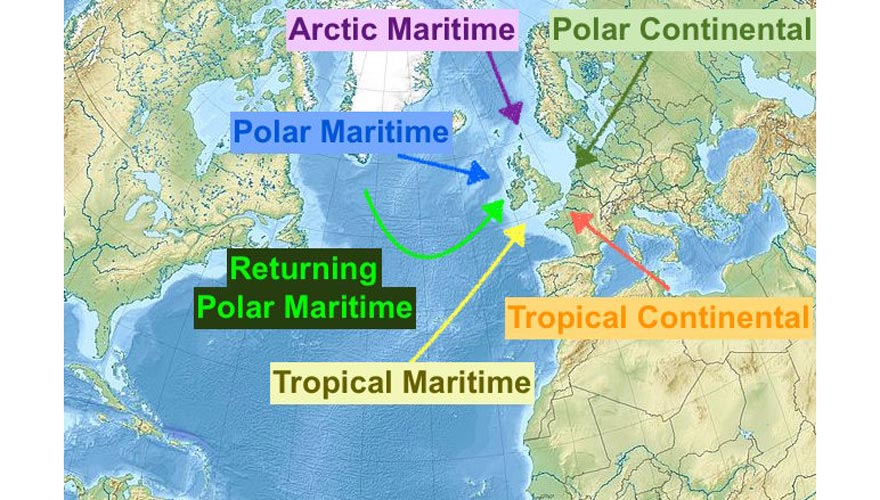
This concept of air masses is perhaps the best way to understand the weather that we get. We refer to these chiefly in terms of where the air originates from - either tropical or polar, continental or maritime. Essentially this boils down to warm or cold, dry, or wet! In reality, the weather story is never quite so simple, but if you get a feel for the standard weather types which these air masses bring, you can be a long way along the road to understanding how our weather works.
Chillier air masses tend to bring showery weather, because there is a greater vertical temperature contrast, or ‘lapse rate’. This makes things unstable, bringing scope for hail and thunder. Lower humidity values in cool air masses can also bring higher cloud bases, clear skies and sunny spells. By comparison, the warmer air masses from the Atlantic can bring murky and drizzly conditions.
Our prevailing weather comes in from the west or southwest, and it just so happens that many of our hills and mountains are found near to our western shores. This means they are first in line to receive everything the Atlantic wants to throw at them.
When moisture laden air arrives, some of it is forced to cross our hills, which induces it to rise. In so doing, the air cools, condenses and forms greater amounts of cloud and rain than if our west coast was pan flat. ‘Orographic rainfall’ is the scientific terminology for the enhancement of precipitation over the mountains. It is fairly common for our western hills to receive daily falls over 100mm under certain weather situations. On the flipside, a process of ‘rain-shadowing’ can mean that on the same day in history, barely a few spots of rain can reach east of the Cairngorms or Pennines for example.
One common air mass is the intriguing ‘hybrid’ which we call ‘Returning Polar Maritime’. That is a regular and rather unwelcome visitor to our shores! It essentially has air which began life over the cooler north Atlantic, making it showery in nature. However, it then makes a journey toward the Azores, scooping up more warmth and moisture, and approaches us from the southwest. The result is generally heavier and more prolonged showers, merging into longer spells of rain!
Weather fronts are the boundaries between air masses and produce what can be called ‘dynamic’ weather - that is where the clash of temperatures causes precipitation processes. Slow-moving frontal ‘waves’ are important rain makers. These systems supply a conveyor belt of moisture over several days, rather than simply clearing through to bring a change of weather.
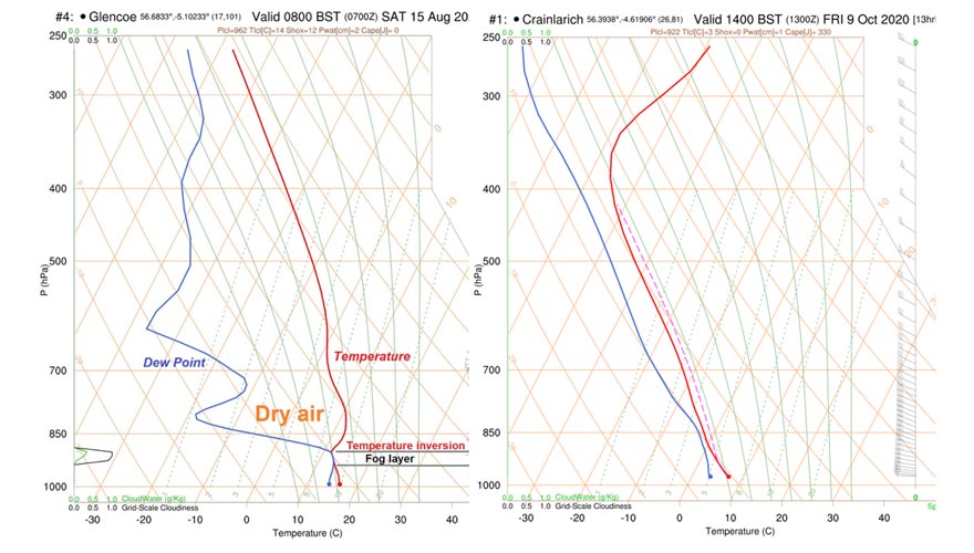
The holy grail of weather in the mountains is the cloud inversion. Those superb days when you climb up through fog to emerge in glorious sunshine, clear air and surprising warmth on higher terrain. These occur best under strongly anticyclonic situations, where high pressure builds over Britain. Under these conditions, air gently descends through the atmosphere above our heads, warming slightly as it does so due to compression. Eventually, this descent reaches the level of our hills, and traps colder, denser air beneath it in the valleys. Any moisture present can then result in fog or low cloud banks lower down, whilst higher up the air is much ‘drier’, and crystal clear.
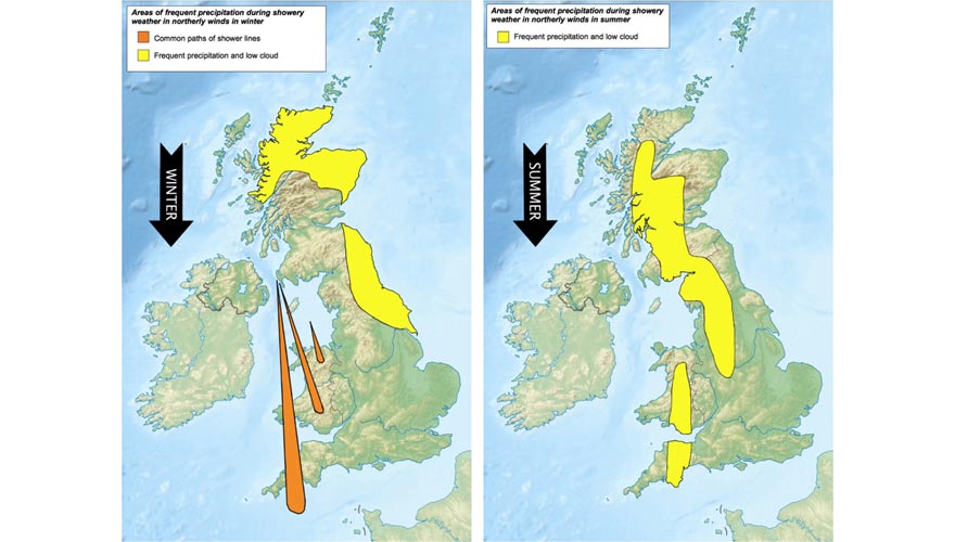
One final piece of the jigsaw of our variable British weather is the irregular shape of our coastline. Local convergence patterns are generated when the airflow aligns to geographic features such as the North Channel between Scotland and Northern Ireland. This forces air through a funnel, encouraging it to rise and trigger showers which are then carried along on the wind direction one after another. These can run into Snowdonia, to give locally constant precipitation, whilst five minutes up the road stays practically dry! In summer, localised coastal sea breezes can modify air movements and trigger ‘hot spots’ of showers in certain locations, depending on the larger scale prevailing wind of the day.
Day-to-day weather forecasting for the British mountains is rarely dull - there’s always something different going on which we have to consider in making our MWIS forecasts! We study a wealth of data from computer modelling around the world to build up a picture of the weather situation. Combine this with the knowledge and experience of our forecasting team, our job is to present this story in a way which prepares you for how the mountains will feel on any given day. Our forecasts are essentially in the form of warnings of the various weather hazards you may encounter, be that wind, rain, fog or temperature.
Our videos aim to compliment our detailed local forecasts by giving the broad weather story for the days ahead, plus some idea of where we think the story is going in the longer range. You can follow all our content on the mwis.org.uk website, plus our YouTube channel and social media feeds.
We've teamed up with Garry and the MWIS to also bring you a weekly weather forecast on the Ellis Brigham Facebook Page. Make sure to tune in every Friday afternoon for a detailed forecast that aids mountain safety.